Highlights from Sacred Destinations
Explore the site
Ahu Tahai The ahu (ceremonial platform) at Tahai sits near a canoe ramp made of rounded beach stones and is thought to be among the earliest ahu structures on the island, dating from 690 AD.
/ Chile / Easter Island (Rapa Nui)
Sacred site · 10th-16th centuries
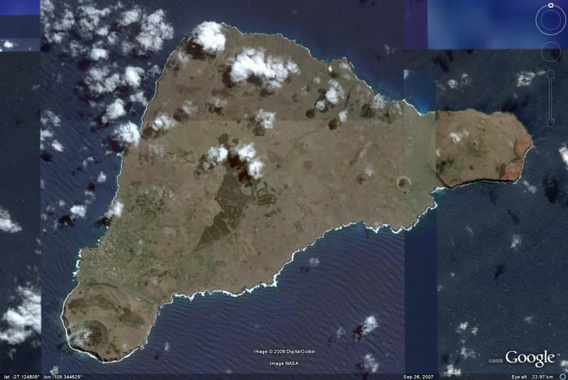
Easter Island (Polynesian: Rapa Nui; Spanish: Isla de Pascua) is an island in the South Pacific belonging to Chile, famous for its colossal statues.
Easter Island (Polynesian: Rapa Nui; Spanish: Isla de Pascua) is an island in the South Pacific belonging to Chile. The name "Easter Island" was given by the Dutch explorer who discovered it on Easter Sunday 1722.
Located in the South Pacific between Chile and Tahiti, Easter Island is one of the most isolated inhabited islands in the world. The nearest inhabited land is Pitcairn Island, 1,290 miles to the west. The triangular-shaped island covers only 64 square miles and was formed out of an ancient volcanic eruption.
Easter Island is famous for its tight-lipped statues that stand across the island, erected by the Rapa Nui people between the 10th and 16th centuries AD. Exactly why and how these ancient wonders were assembled is still not fully understood.
Although many imaginative theories have been offered for the origins of the Easter Island people and statues, archaeologists and historians believe they have a reliable outline of most of the island's history.
Easter Island's human history began with the settlement of the island by Polynesians around 400 AD, who probably arrived from the islands of Mangareva or Pitcairn to the west. These Polynesian settlers brought bananas, taro, sweet potato, sugarcane, paper mulberry and chickens and established a relatively advanced and complex civilization.
"Easter Island" is of course a European name, but even "Rapa Nui" was not the original name for the island. It was coined by labor immigrants from the original Rapa in the Bass Islands who likened it to their home island. The Rapanui name of Rapa Nui is Te pito o te henua ("Navel of the World") due to its isolation, but this too seems to be derived from another location, possibly a Marquesan landmark.
The European discovery of the island, by the Dutch navigator Jakob Roggeveen, occurred in 1722 on Easter Sunday. Roggeveen found about 2,000-3,000 inhabitants on the island, but it appears that there were as many as 10,000-15,000 of them in the 16th and 17th centuries. The civilization of Easter Island had already degenerated drastically during the 100 years before the arrival of the Dutch, owing to the overpopulation, deforestation and exploitation of the extremely isolated island with its limited natural resources.
Easter Island has very few trees, but this was not always the case. The island once possessed a forest of palms, but it seems the native Easter Islanders completely deforested the island in the process of erecting their statues, as well as constructing fishing boats and buildings. There is evidence that the disappearance of the island's trees coincided with the collapse of the Easter Island civilization. Midden contents from that time period show a sudden drop in quantity of fish and bird bones as the islanders lost the means to construct fishing vessels and the birds lost their nesting sites. Chickens and rats became leading items of diet. There is also some evidence of cannibalism.
The small surviving population of Easter Island eventually developed new traditions to allot the few remaining resources. In the cult of the Birdman (manutara), a competition was established in which every year a representative of each tribe, chosen by the leaders, would dive into the sea and swim across to Motu Nui, a nearby islet, to search for the first egg laid by a Sooty Tern during the season. The first swimmer to return with an egg would secure control of the island's resources for his tribe for the rest of the year. This tradition was still in existence at the time of first contact by Europeans.
However, by the mid-19th century the population had recovered to about 4,000 inhabitants. Then in a mere 20 years, deportation to Peru and Chile and diseases brought by Westerners almost exterminated the whole population, with only 111 inhabitants left on the island in 1877. The island was annexed by Chile in 1888 (by Policarpo Toro). The native Rapanui are gradually recovering from their low population levels.
Today, the tremendous increase of tourism on the island coupled with a large inflow of people from mainland Chile are threatening to alter the Polynesian identity of the island. The possession of the land has created political tensions in the past 20 years, with part of the native Rapanui opposed to private property and in favor of the traditional communal property of their ancestors.
The civilization of Easter Island had already degenerated drastically during the 100 years before the arrival of the Dutch, owing to the overpopulation, deforestation and exploitation of the extremely isolated island with its limited natural resources.
Then in a mere 20 years, deportation to Peru and Chile and diseases brought by Westerners almost exterminated the whole population, with only 111 inhabitants left on the island in 1877.
The ahu (ceremonial platform) at Tahai sits near a canoe ramp made of rounded beach stones and is thought to be among the earliest ahu structures on the island, dating from 690 AD. It was restored by the American archaeologist William Mulloy.
The island's famous moai statues were made from the volcanic rock of this mountain quarry and are scattered across its slopes in various stages of completion.
A hike to the summit of this 400m volcano offers panoramic views of the island's solitude in the South Pacific.
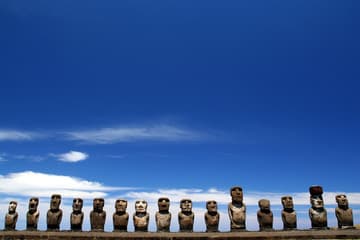
15 of the island's famous moai statues stand here in a military lineup upon a flat rock platform.
This lake-filled crater is filled with remnants of the Birdman cult practiced until 1867.
Highlights from Sacred Destinations
Highlights from Sacred Destinations
Advertisement
Advertisement
Advertisement
Where on earth