Highlights from Sacred Destinations
Explore the site
Since 1993, the 2470-acre site that includes the Kabah ruins has been a designated conservation area (Parque Estatal).
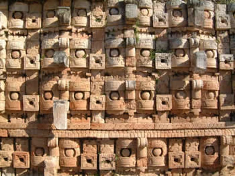
/ Mexico / Kabah
Chac · 9th-12th centuries AD
Located 18 km from Uxmal, Kabah was at its peak from 800 to 900 AD. The ruins feature elaborate carvings of the rain god Chac and fine examples of the Maya vault.
Kabah is a Mayan site on the Yucatán Peninsula connected to nearby Uxmal by a ceremonial causeway. Its buildings date from about the 9th century and are in the Puuc style of architecture. Kabah is best known for its extraordinary palace that is completely covered in masks of the hook-nosed rain god Chac.
This area was inhabited by the 3rd century BC, but the principal buildings on the site date mostly from the 9th century AD (a sculpted date of 857 was found on one of the doorjambs). Kabah was abandoned by around 1200.
Not much is known about the history of Kabah, but It seems to have been a dependency of the great city of Uxmal. The two centers are linked by a sacbé, a Mayan "white road" used for ceremonial purposes.
The site was first explored in the mid-19th century by John Lloyd Stephens and Frederick Catherwood and the first systematic digs were carried out by Teobert Maler towards the end of the century. Later somewhat neglected by archaeologists, investigation of Kabah resumed in 1990.
A program began in 2003 to clear and restore more buildings and archeological excavations continue under the direction of Ramón Carrasco.
This area was inhabited by the 3rd century BC, but the principal buildings on the site date mostly from the 9th century AD (a sculpted date of 857 was found on one of the doorjambs).
Kabah was abandoned by around 1200.
Since 1993, the 2470-acre site that includes the Kabah ruins has been a designated conservation area (Parque Estatal). The ruins extend for a considerable distance on both sides of the highway and many of the more distant structures are little visited; others are still overgrown with forest.
A sacbé, or Mayan ceremonial causeway, links Kabah with Uxmal. It is a raised pedestrian walkway 5 meters wide with ceremonial arches at each end.
All the buildings excavated so far at Kabah are in the traditional Puuc style, but they have also revealed unusual features attributed to Chenes influence.
The style called Puuc is named after a string of low hills that extend from western Campeche into the state of Yucatán. Puuc sites are very numerous and clearly were the focal point for Maya artistic and intellectual culture in this area. Typical characteristics of the Puuc style include (according to Encyclopædia Britannica):
The most notable structure at Kabah is the Palace of the Masks or Codz Poop (meaning "Rolled Matting"), which has a facade covered in hundreds of stone masks of the hook-nosed rain god Chac. This massive repetition of a single set of elements is unusual in Maya art and makes for an impressive sight.
Highlights from Sacred Destinations
Highlights from Sacred Destinations
Advertisement
Advertisement
Advertisement
Where on earth