Chichén Itzá, Mexico
Chichén Itzá (pronounced "chee-CHEN eet-ZAH") is the largest of the ruined Mayan cities on the Yucatán Peninsula and one of Mexico's most-visited tourist destinations. Construction began in the 7th century and the city reached its peak after the arrival of the Toltecs in the 10th century.
History of Chichén Itzá
Although many excavations have been carried out and tour guides tend to speak with an air of certainty, most of what is said about Chichén Itzá is merely an educated guess. But it is at least fairly certain that this area was settled by farmers as early as the 4th century and an urban society, with construction of the first temples, appeared in the 7th century.
In this early period, stone temples and palaces were constructed in the traditional Puuc Maya style. These buildings can be found in the "Old Chichén" section of the city and most are dedicated to the rain god Chac. Construction continued for a couple hundred years.
In the 10th century (the post-Classic era), the city came under the rule of the Itzáes, who arrived by way of the Gulf coast. They may have been a mix of highland Toltecs (the people who built the city of Tula in central Mexico) and lowland Putún Maya, a commercial people thriving on trade between the different regions of the area.
In the following centuries, Chichén Itzá saw its greatest growth and soon became the most powerful city in the Yucatan. Most of the grand architecture was built during this age, in a mixture of Maya and Toltec styles. The new rulers may actually have been refugees from the Toltec city of Tula. The new ruler called himself "Kukulcan," the name of the Mesoamerican Feathered Serpent god (also known as Quetzalcoatl) and Chichén Itzá became a center for worship of that god as well.
There is a mythological story told in pre-Columbian central Mexico about a fight that occurred between the gods Quetzalcoatl and Tezcatlipoca, which resulted in Quetzalcoatl being forced to leave his homeland and venture east. This may be a shorthand account of a civil war in Tula that ended with the losers fleeing to the Yucatán, where they were welcomed by the local Maya. Over time, the Itzaés adopted more and more of the ways of the Maya.
Sometime at the end of the 12th century, the city was captured by its neighbor and rival, the city of Mayapán. Chichén Itzá was not abandoned, but as political power shifted elsewhere it declined and no major new buildings were constructed. Chichén Itzá remained a place of pilgrimage for the Maya until it was conquered by the Spanish Conquistadors in the 16th century.
The structures of Chichén Itzá were overgrown with jungle and slowly decayed until major archaeological excavations began in the 1920s. Ever since, more of the ancient structures have been cleared and restored and more and more tourists have come to visit.
What to See at Chichén Itzá
It can take a whole day to see the extensive ruins of Chichén Itzá, which occupy 2.5 square miles. At the entrance is a large, modern visitors' center that includes a museum, a restaurant, bathrooms, and a bookstore. Here there are licensed guides who speak Spanish or English available for hire. A guide is not necessary, especially if you have a map or guidebook, but he or she can point out details you might otherwise miss and tell interesting stories about the ruins.
The site has two areas: the central "new" zone, which shows distinct Toltec influence, and the southern "old" zone, with mostly Puuc architecture. The most well-known monuments are in the new zone.
Across from the main entrance in the center of an open court is the towering pyramid known as El Castillo (the Castle) or the Pyramid of Kukulcan. Dedicated to the feathered serpent god Kukulcan, this is the most famous landmark of Chichén Itzá.
The architecture of El Castillo is full of symbolism, particularly with reference to the important Mayan calendar. The four stairways leading up to the central platform each have 91 steps, making a total of 364; added to the central platform this equals the 365 days of the solar year. On either side of each stairway are nine terraces, which makes 18 on each face of the pyramid, equaling the number of months in the Maya solar calendar. On the facing of these terraces are 52 panels, representing the 52-year cycle when both the solar and religious calendars would become realigned.
Sculptures of the Feathered Serpents run down the sides of the northern staircase and are aligned so that a special effect occurs on the spring and fall equinox. On these two days, the setting sun casts the shadow of the terraces onto the ramp of the northern stairway, forming a diamond pattern suggestive of the designs on some snakes. Slowly it descends into the earth.
Carefully climb up one of the steep staircases for a great view of the site and some carvings in the temple on top. The Maya would often build newer bigger temple-pyramids atop older ones and archaeologists have constructed tunnels allowing a view of an earlier temple of Kukulcan inside the later one. A narrow stairway at the western edge of the north staircase leads inside the early temple, where you can see King Kukulcan's Jaguar Throne, painted red and encrusted with jade spots. The stairway is open from 11am to 3pm and is cramped, usually crowded, humid, and uncomfortable - not for those with claustrophobia. A visit early in the day is best. Photos of the jaguar figure are not allowed.
Chichén Itzá is home to no less than nine ball courts, which hosted the famous Mayan ball game. The largest one, the Juego de Pelota (Main Ball Court) is northwest of El Castillo. It is the largest and best-preserved ball court in the Mayan world. Both walls are carved with scenes showing Maya figures dressed as ball players and decked out in heavy protective padding. There is also a headless player kneeling with blood shooting from his neck, while another player holding the head looks on.
The acoustics of the ball court are so good that from the North Temple, a person speaking can be heard clearly at the opposite end, about 443 feet away. Between this and the fatal consequences of losing (or winning - some scholars suggest the winners would have made more fitting sacrifices), the games must have been quite a spectacle.
There is a temple at each end of the ball court. The North Temple has sculptured pillars and more sculptures inside, as well as some murals in bad shape.
Near the southeastern corner of the ball court is the Temple of the Jaguars, a small temple with serpent columns and carved panels showing warriors and jaguars. Inside, a mural was found that chronicles a battle in a Maya village.
To the right of the ball court is Tzompantli (Temple of the Skulls), whose theme comes from the post-Classic cities of central Mexico. It is named for the rows of skulls carved into the stone platform, which represent the heads of sacrificial victims. When the victim's was cut off, it was impaled on a pole and displayed in a tidy row with others. Also carved into the stone are pictures of eagles tearing hearts from human victims. The word Tzompantli is not Mayan but comes from central Mexico.
Next to the Temple of the Skulls, the small Platform of the Eagles has reliefs showing eagles and jaguars clutching human hearts in their talons and claws, as well as a human head emerging from the mouth of a serpent.
East of the Skulls and north of El Castillo, near the road to the Sacred Cenote, is the Platform of Venus. In Maya and Toltec lore, a feathered monster or a feathered serpent with a human head in its mouth represented Venus. This is also called the Tomb of Chac-Mool because a Chac-Mool figure was discovered "buried" within the structure.
From the Platform of Venus, an ancient sacbé, or ceremonial causeway heads north to the Sacred Cenote (5 minutes' walk). This great natural well may have given Chichén Itzá ("Well of the Itzáes") its name. This well was used for ceremonial purposes: sacrificial victims were thrown in.
Bones of both children and adults have been found in the well, along with a fortune in gold and jade. These were dredged out by Edward Thompson, the American consul in Mérida and a Harvard professor, who purchased the ruins of Chichén early in the 20th century.
Most of the riches wound up in Harvard's Peabody Museum of Archaeology and Ethnology, to the chagrin of Mexican classicists still today. Excavations in the 1960s unearthed more treasure, and studies of the recovered objects detail offerings from throughout the Yucatán and even farther away.
East of El Castillo is one of the most impressive structures at Chichén: the Templo de los Guerreros (Temple of the Warriors), named for the carvings of warriors marching along its walls. It's also called the Group of the Thousand Columns for the rows of broken pillars that flank it. During the recent restoration, hundreds more of the columns were rescued from the rubble and put in place, setting off the temple more magnificently than ever. A figure of Chaac-Mool sits at the top of the temple, surrounded by impressive columns carved in relief to look like enormous feathered serpents.
South of the temple was a square building that archaeologists call El Mercado (The Market); a colonnade surrounds its central court. Beyond the temple and the market in the jungle are mounds of rubble, parts of which are being reconstructed.
The main Mérida-Cancún highway once ran straight through the ruins of Chichén Itzá, and though it has been diverted, you can still see the great swath it cut. South and west of the old highway's path are more impressive ruined buildings.
Past the snack bar to the right of the path is the Tumba del Gran Sacerdote (Tomb of the High Priest), which stood atop a natural limestone cave in which skeletons and offerings were found, giving the temple its name.
The next building on the right is known as the Casa de los Metates (Temple of the Grinding Stones),after the concave corn-grinding stones used by the Maya. Past this temple is the Templo del Venado (Temple of the Deer), a fairly tall but ruined building. The relief of a stag that gave the temple its name is long gone.
The next temple has been dubbed Chichan-Chob (Little Holes) and features a roof comb with little holes, three masks of Chaac, three rooms, and a nice view of the surrounding structures. One of the oldest buildings at Chichén Itza, it was built in the Puuc style during the late Classic period.
El Caracol (The "Snail" or Observatory) was constructed over several centuries; the additions and modifications reflect the Mayas' careful observation of celestial movements and increasingly exact measurements. Through slits in the tower walls, Mayan astronomers observed the cardinal directions, the approach of the spring and autumn equinoxes, as well as the summer solstice. The Spanish name, which means "snail," was inspired by a spiral staircase inside.
East of El Caracol, a path leads north into the bush to the Cenote Xtoloc, a natural limestone well that provided the city's daily water supply. This cenote is named for the xtoloc species of lizard, which can still be seen among the ruins.
The Templo de los Tableros (Temple of the Panels), just south of El Caracol, is named for the carved panels on top. This temple was once covered by a much larger structure, only traces of which remain. Nearby are the ruins of a temazcalli (steam bath).
The enormous Edificio de las Monjas (Nunnery) is quite similar to the palaces at the Puuc sites of Kabah, Sayil, Labná and Xlapak. Built in the late Classic period, the new edifice was constructed over an older one. Suspecting this, the early 20th-century archaeologist Le Plongeon blew away part of the exterior with dynamite, revealing the older structures within. You can still see the results of Le Plongeon's not-so-precise exploratory methods.
On the east side of the Nunnery is Anexo Este (Annex) constructed in highly ornate Chenes style with Chac masks and serpents.
Next to the annex is one of the oldest buildings at Chichén Itzá, dubbed La Iglesia (the Church). Masks of Chac decorate two upper stories. Among the crowd of Chacs there are also an armadillo, a crab, a snail, and a tortoise. These represent the Maya gods, called bacah, whose job it was to hold up the sky.
Akab Dzib (Temple of Obscure Writing) lies east of the Edifice of the Nuns. Above a door in one of the rooms are some Mayan glyphs, which gave the temple its name (the writings have yet to be deciphered). In other rooms, traces of red handprints are still visible. Reconstructed and expanded over the centuries, Akab Dzib may be the oldest building at Chichén Itzá.
For a look at more of Chichén's oldest buildings, constructed well before the time of Toltec influence, follow signs from the Edifice of the Nuns southwest into the bush to Chichén Viejo (Old Chichén), about 1/2 mile away. Be sure to have long pants, insect repellent, and a local guide with you.
The attractions at Chichén Viejo, some of which have been recently restored, include the Templo de los Inscripciones Iniciales (Temple of the First Inscriptions), with the oldest inscriptions discovered at Chichén, and the Templo de los Dinteles (Temple of the Lintels), a fine Puuc building.
Getting There
Chichén Itzá is on old Highway 180 between Mérida (1.5 hours away) and Cancún (2.5 hours away).
By car, the fastest way to get to Chichén Itzá from either city is to take the autopista (or cuota). The toll is $7 from Mérida, $22 from Cancún. After exiting the autopista, turn onto the road leading to the village of Pisté. In the village, you'll reach a T junction at Highway 180 and turn left to get to the ruins. The entrance to the ruins is well marked. If you stay on the highway for a few kilometers more you'll come to the exit for the hotel zone at kilometer marker 121.
Chichén Itzá can also be reached by bus. From Mérida, there are three first-class ADO buses per day. There are also a couple of first-class buses to Cancún and Playa. Otherwise, you can buy a second-class bus ticket to Valladolid and a first-class from there. If you want to take a day trip from Mérida or Cancún, go with a tour company.
Many visit Chichén Itzá as a day trip from Cancun or Mérida, but to really appreciate and enjoy the site it is best to stay overnight at one of the site's hotels. This way you can take your time, catch the sound and light show at night (already included in the price of admission) and return the next morning when it is cool and before the tour buses arrive.
Quick Facts on Chichén Itzá
| Site Information | |
| Names: | "Well of the Itzáes" · Chichén Itzá |
|---|---|
| Categories: | archaeological sites; temples; World Heritage Sites |
| Styles: | Maya civilization |
| Dates: | 7th-12th centuries |
| Status: | ruins |
| Visitor and Contact Information | |
| Coordinates: | 20.683561° N, 88.569031° W |
| Address: | Mexico |
| Hours: | Daily 8-5 |
| Lodging: | View hotels near Chichén Itzá |
References
- Pre-Hispanic City of Chichen-Itza - UNESCO World Heritage List
- Lynne Bairstow, Frommer's Cancun, Cozumel and the Yucatan 2007
More Information
- Chichen Itza - TripAdvisor traveler reviews and tips
- Photos of Chichén Itzá - here on Sacred Destinations
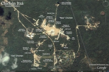
Map of Chichén Itzá, Mexico
Below is a location map and aerial view of Chichén Itzá. Using the buttons on the left (or the wheel on your mouse), you can zoom in for a closer look, or zoom out to get your bearings. To move around, click and drag the map with your mouse.